What is a "Catchment" or "Sub-catchment"?
Sub-catchments are defined in CD 535 as “The separate carriageways of a catchment, used primarily for flood risk assessment.”
Catchments and sub-catchments are a re-segmented version of the road network model, with the catchment boundaries being based on high points on the road network. Each catchment includes one or more sub-catchment, usually so each carriageway is a seperate sub-catchment. Each catchment is associated with one Area:
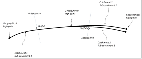
Catchments and their sub-catchments are defined within GDMS and are read only.