GADGET
The Geotechnical Asset Data Graphical Earthwork Tool (GADGET), used for location-based visualisation, is a key part of TabletGAD and is used in the field for viewing, creating and editing objects. The layout of GADGET and summary of main components are shown below:
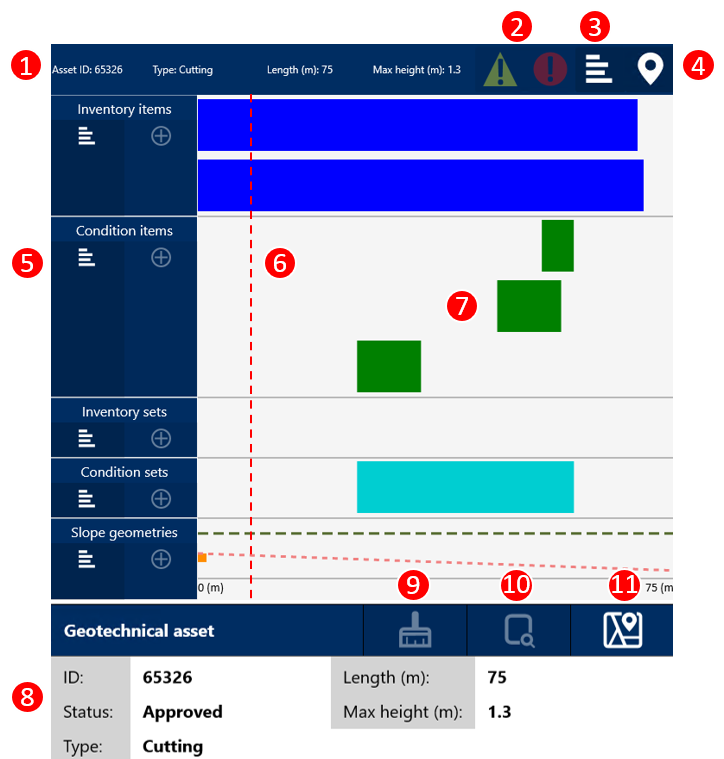
The main components are:
-
Key geotechnical asset information
-
Outstanding actions buttons - highlights the objects that require actions
-
Asset contents button
-
Refresh location - updates GPS location (6)
-
GAD object buttons
-
View details
-
Create new - greyed out if not available
-
-
Current location
-
GAD object extents - select to see key information
-
Selected object key information
-
Clear selection
-
Selected object details
-
View object on map
Selecting objects
Objects can be selected and deselected by pressing them in GADGET. When selected any associated items are highlighted with dashed lines, this includes items in a set or an inventory item associated to a condition item.
Multiple objects can be selected at once, only the key information for the most recently selected object will be shown. Multiple items can be selected and added to a new set by pressing the 'Plus' button for a set.
Press the clear selection (9) to remove all selections. When no objects are selected asset information will be shown in object details (10).
Outstanding Actions
There are two different outstanding action buttons:
-
Recommend action (yellow triangle) - highlights all objects with recommended actions, such as a recommended confirm.
-
Required action (Red circle) - highlights all objects with required actions, such as objects with missing end locations.
GPS Location
A red bar shows your location along the extents of the asset (6). This can be updated by pressing the refresh location button (4).
Slope Geometry
Slope geometries are shown with slope height plotted on the y-axis, to give a view of how asset height changes along its length. The green dotted line is fixed at 2.5m as a reference.